I’ve been looking forward to a longer cycling excursion after what has been a record breaking, brutally hot, and drought plagued summer in Austin this year. October can have highly variable weather as summer slowly recedes. It can be pushing a 100F one day and near frosty the following morning if a severe cold front blows in. I’ve been wanting to do a bikerafting trip on the Devils River ever since I moved back to Austin, but the ongoing drought has the rivers at low levels and very low flows. I decided instead to make another trip to the coast on the TCBR where the drought would not be a problem.
The climate on the coast is typically more moderate without the temperature extremes on either end, but the winds and rain associated with fronts can be magnified. I didn’t have an exact date in mind for setting out, but I did want to wait until the temperature dropped a bit to make the ride down to the coast enjoyable and not embark in severe stormy weather. The only limitation on time for this trip was to be back in Austin before Halloween. I had no intention of doing this as a time trial, but I also didn’t want to doddle about. Optimally, I would have enough time to complete the trip without feeling rushed.
Normally I put out an open invite for rides and trips of this sort, but without a precise start date in advance (or return date 😆), I decided it was best to roll this one solo. There is also the additional equipment requirements of this trip, like the need for big tires, a packraft, and a camping setup that works on a beach, that limits accessibility of this route for most people. This is a bit of a double edge sword as the inaccessibility of the route ensures that I get those bits of wilderness experience that I enjoy, but limits the possibilities for bringing friends along for the ride.
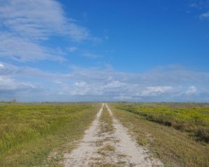
Getting to the start of the TCBR and getting back to Austin can also be a bit impracticable. It’s at least 350 miles of driving (~6 hours) to get to South Padre Island by the fastest car route. I decided to start the ride in Austin, as I did last time, and take the same multi-day route down by bike. Reaching the coast at Port Aransas on the third day of riding, I would then ride the lower portion of the route as an out and back before continuing up the coast. Similarly, I would ride back from the end of the route to Austin over the course of a few days either using my previous routes or rambling on some new route.
On the morning of Thursday October 12th I rolled out at 7 am which gave me a full 19 days to complete my trip and make it back to Austin. My generous estimates for a more relaxed pace were 4-5 days to reach the southern terminus, a week to ride up the coast, and then 3-4 days to ride back to Austin. Optimally this would take around two weeks and it left a nice buffer of extra time for rest days, bad weather/beach conditions, or some unforeseen problems, obstacles, or detours.
Day 1: Austin -> Palmetto SP
I headed out on a Thursday morning and rode my usual route down to Palmetto State Park. The morning was wetter than expected with a constant mist, but not unpleasant as the cooler temperatures were welcome. Unfortunately, I crashed just as I was leaving the city of Kyle. A roundabout near the high school was coated in a thick layer of oil and grease which combined with the mist to make an extra slick surface. I slid out and went down fairly hard on my left side, but the surface was so slick that I continued sliding on the road. I quickly got up and out of the road to assess my injuries and found that my arm and legs were coated in a layer of black oil/grease from the road. While being the cause of the crash, it had spared me from most of the usual road rash. I had a small abrasion on my elbow and some friction burns on my ankle but they weren’t really bleeding and the bike and my gear with the exception of my sunglasses appeared fine. I was not wearing the sunglasses at the time because of the mist and they had been secured through the webbing loops on my handlebar bag. They had some small scratches on the lenses from the crash but were still usable for the remainder of the trip. Of the three Texas coast trips, I’ve never completed one without destroying a pair of sunglasses, but I always take cheap ones on these trips so it’s no big loss. I had a few aches from the crash, but I decided that this was no reason to turn around and continued on. Later I noticed that I had popped a rib also. Wasn’t a problem, but I couldn’t sneeze without doubling over in pain for about 3 weeks and the popping in and out of place of the rib was a bit unsettling at times.
After the crash, the remainder of the ride to Palmetto SP was nice. I stopped in the city of Luling at the HEB to grab some food, extra hydrocolloid bandages, and ibuprofen in case I needed them. I arrived at the park before it got too warm, setup the camp site, and took a nice shower to get cleaned up, remove all the stubborn remaining oil/grease, and clean the wounds well. Afterwards, I spent the day enjoying the park.
Palmetto SP is a great small state park that preserves and showcases an unusual environment for this part of Texas. Within the park are boggy wetlands of the Ottine swamp that are home to the abundant dwarf palmettos that the park is named for and contributing to the jungle feel. A swamp is an unusual thing in this part of Texas and is sustained by sulfur springs and the San Marcos river (itself originating as a very large spring) which runs accessibly through the park. The park also has a small 4 acre oxbow lake that was initially formed from flooding of the river but is now fed from an artesian well and springs. I took the packraft out and paddled the oxbow lake during the day and rode all the trails later in the afternoon.
While still being a great place for a camping retreat, I always get the feeling that Palmetto SP presents a warning to us in central Texas. The Ottine swamp was historically much larger and more springs brought water to the area. A sign on the trail marks the location of extinct mud boils where spring water pushed up through the ground but disappeared in the early 1970’s. Drilling of wells and the lowering of the water table are thought to be the culprits in this disappearance. As the ongoing drought in the area and back in Austin persists, it’s hard not to think that the ever growing population’s need for water and the increasing aridity of the region will continue to lead to losses of these spring fed wonders.
Day 2: Palmetto SP -> Goliad SP
I set out early on the second day to Goliad. The weather was again mild with a light headwind. I followed the same route as I had on previous trips which is fine even though it does it include some long stretches of lightly utilized highway. The first 20 miles is almost entirely quiet gravel roads through farm land. Then about 45 miles of pavement of Farm to Market type roads with a short bit of shoulder riding on the state highway. I could probably reduce this by substituting in some alternate side routes for this section at the cost of more distance and time, but it hasn’t bothered me on any of my trips so I haven’t felt the need to alter my route. The final stretch of pavement was Old Goliad Road and I always enjoy riding it.
I had not been able to reserve a camp site in advance as the park was completely full. I booked a cheap motel in town and then visited the park and surrounding sites via the Angel of Goliad Hike and Bike Trail. The trail begins at the Branch River Park near the town square, runs down a series of wooden switchbacks, crosses through the state park, across the river, and up to more historical sites on the other side. In contrast to Palmetto SP’s nature focus, Goliad SP is primarily a historical site.
The most prominent historical site in the park is Mission Espíritu Santo. Spanish missionaries established the Nuestra Señora del Espíritu Santo de Zuñiga mission near Matagorda Bay in 1722 but moved it inland to this location at Goliad in 1749. The mission was abandoned in 1830 and left to ruin. In the 1930’s the Civilian Conservation Corps restored the mission after the state accepted the land for a park. Adjacent to the park is the Presidio la Bahía State Historic Site, a fort constructed by the Spanish Army at the same time as the mission which played roles in both the Mexican War of Independence and Texas Revolution. Also adjacent is the birthplace of Mexican general and politician Ignacio Zaragoza, who led the battle that is celebrated on Cinco de Mayo, and the Fannin Memorial Monument, commemorating the Goliad Massacre.
Day 3: Goliad SP -> Padre Island National Seashore
The third day is where things really get rolling as far as a coast trip goes. I headed out just before sun up and rode mostly quiet roads toward the coast. This was a special day because I was going to be in the optimal path of the 2023 Annular Eclipse. I had a goal of arriving on the beach at Port Aransas before the eclipse which would be just before noon. I crossed from Aransas Pass to Port Aransas on the ferry. I had forgotten to pack my eclipse glasses, but some fellow observers shared a pair with me on the ride across to look at the beginnings of the eclipse. Afterwards I rode straight to the beach and arrived just a few minutes before the peak of the eclipse. It was a strange spectacle to see a beach packed full of people staring at the sun. After the eclipse, I started riding south on the beach. There were a couple spots along the way that I hadn’t previously ridden because the highway runs right along the coast and I’d previously opted to ride around some of those sections. This region of beach can be particularly busy. I was surprised by how many people were fishing at the jetties at Packery Channel which separates Mustang Island from North Padre Island. I did a quick loop around to use the bridge and returned to the beach. I rode back up the small section to the south jetty which includes a seawall and then proceeded south.
It didn’t take long to get outside of this developed beach area and the ride down to Padre Island National Seashore on the less populated beach was nice. I decided to camp at the Malaquite Campground near the park entrance on the north end. This was my first time camping at this established campground. It’s a small campground and doesn’t have much in the way of amenities. It has unheated showers and bathrooms and that’s about all. It also doesn’t take reservations and all the sites with areas for tents were taken as expected being a Saturday so I decided to pitch my tent on the beach. I was greeted by a camp host as I rolled in who was very excited to see someone roll in on a bike to camp out there. They were very welcoming and asked if there was anything I needed. They talked about being a “trail angel” and helping out thru-hikers somewhere else in the past. Being well supplied at this point I kindly thanked them for their generosity and told them we’d chat more later. It was starting to get later in the afternoon so I was focused on getting camp setup and a shower. After getting things situated and cleaned up I still had a bit of time so I rolled down to the Malaquite Visitor Center which is about a half mile down the beach. I have never stopped at the small park store so I stopped by. Not much in the way of food and snacks so definitely bring plenty with you.
Day 4: Padre Island National Seashore (PINS) -> South Padre Island
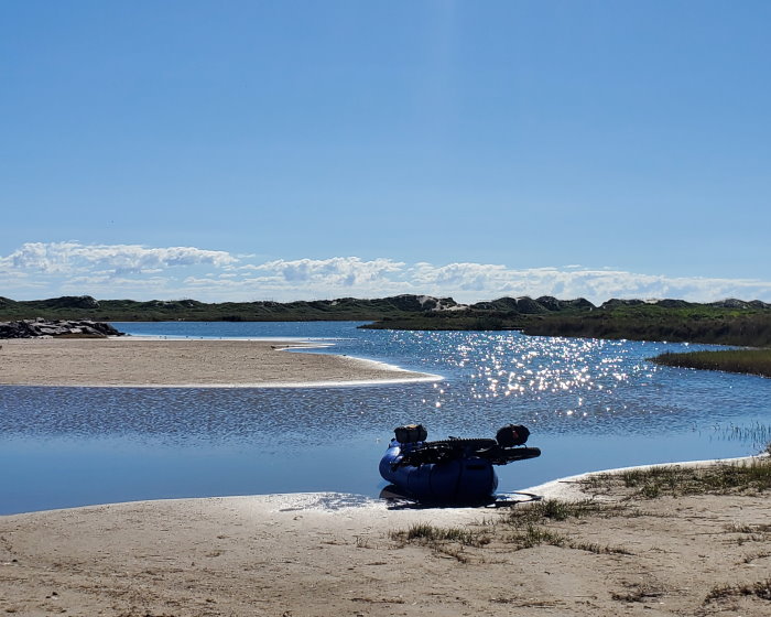
I broke camp early and was on my way down the beach as the sun was rising. It’s over 80 miles of sand and one water crossing before I would get back to a road of any kind. With this in mind, I had packed plenty of water as there is also no fresh water source along this stretch. I hadn’t planned a specific stopping point for the day as PINS can be a slow ride if the weather and tides don’t cooperate. Fortunately, a favorable tailwind picked up as I rode and the beach conditions were pretty good. I made it to the Mansfield Channel, which separates North Padre from South Padre Island, by about 11 am.
I left the beach and followed the sandy double track behind the jetty to where I cross by raft. There was a few guys fishing near where I usually launch that had arrived by boat. One of the guys walked over and introduced himself while I unpacked the raft and began inflating it. His name was Ryan and he was quite interested in my rafting setup and trip so we chatted for awhile as I went about setting things up. He offered me a beer and introduced me to the rest of the fisherman. It turned out that he was also form Austin. We all chatted for awhile and then I prepared to launch my raft.
I made my way quickly across the channel and packed things up. I should have checked the area behind the jetty on that side before packing up as it is prone to flooding. I could have set the raft back up and floated across this area, but I decided that I would try scrambling on the back end of jetty past the flooded area. I wouldn’t recommend that anyone do this as it is a bit difficult with a heavily laden bicycle, but I made it across without incident in less time than it would have taken to setup the raft, paddle across the flooded area, and then pack everything back up. As I made my way back to the beach I happened upon a group trying to free a stuck pickup truck by pulling with another pickup. I did not take a picture of the effort to free the truck as all involved appeared to be tired and unhappy.
I decided that I would continue on to the city of South Padre Island at the southern most end of the island since I was making good time. The next 23 miles passed quickly and I only stopped for a few pictures. I then hopped on State Park Rd 100 where it emerges from the sand to finish the last few miles into town and avoid the crowds on the developed beach. I had now reached the southern most point of my route so I decided to take a rest day the next day. This would be good timing as the cold front was now blowing in with severe winds that would make rafting impossible and cycling extremely unpleasant.
Day 5: The Rest Day
I began the day with a nice walk on the beach. The cold front had arrived and the wind was blowing with gusts around 30 mph, but the temperature was still in the low 70’s. Afterwards I visited the sand sculpture installation from the previous weekends Sand Castle Days sculpting competition. I tried to keep everything as leisurely and restful as possible while enjoying the local food and sights. I didn’t record any riding on this day though I made some short quick trips for food, laundry, and supplies.
Day 6: South Padre Island -> Padre Island National Seashore (PINS)
Having rested well, I set out to head back up the coast. I knew that it was going to be a solid headwind day so I brought plenty of water and supplies in case progress was severely impaired. I reached the Mansfield Channel around 10 am. The truck that I had seen stuck a couple days ago was gone, and I made my way behind the jetty. The area behind was still flooded so I setup my raft there and paddled across the small lagoon. Once across, I unloaded the raft except for my bike and carried it the short ways over the sand to get to the launch point to cross the channel. I crossed the channel and then began packing things up when a large brown pelican landed beside me. At first I was concerned that maybe I had invaded the bird’s territory. However, it quickly became clear that the bird was not trying to chase me off. I think it wanted me to give it a fish, but I did not have any. After I packed up, I bid farewell to the bird and headed around to the beach to continue north.
It was a slow roll up the 60 miles of PINS due to the headwind, but a low tide helped with good beach conditions. Being a weekday, I encountered few people for the first half. The only negative encounter I had with anyone on the entire trip was at about the halfway point. Three guys had setup fishing with poles and lines running out into the surf, parked trucks blocking the upper beach, and a small shelter area setup kind of in the middle. Normally, I would wave and pass on my way, but they had three off leash dogs running around. I dismounted and tried to pass, but the dogs were aggressive and would not let me pass. I asked the guy walking around to get his dogs under control, but he was incapable and seemed drunk. We exchanged some words, and I eventually got past.
I spotted two hikers about 20 miles from the north end of the park. I recognized them from a news article that I had seen a few weeks ago about a couple walking then entire Texas coast to produce a documentary called ‘Chasing the Tide.’ I circled back and chatted with them for a few minutes about our trips. They snapped a selfie with me and then we parted ways in the opposite direction.
I rolled into the Malaquite Campground again that afternoon which was much less busy on this Tuesday. I was able to get a camp site with a nice spot to pitch my tent. I ran into the camp host again who was excited to hear about my trip.
I went out on the beach at night with my head lamp for a walk and maybe get some pictures of the night time beach inhabitants like the ghost crabs. As i walked down the beach, I saw four pairs of eyes brightly glowing back at me from the reflection of my headlamp. They seemed to stay focused on me, and move about, keeping there distance as I walked onward. At first I thought they were nuisance racoons as established campsites like the one on the other side of the dunes often attract such visitors. As I continued walking down the beach I noticed that the quick movements of the glowing eyes was unlike my encounters with racoons. Eventually I took a little sprint down the beach and got within range with my headlamp to see who was watching me. It was four coyotes which quickly dashed away after sensing that I had gotten close.
Day 7: Padre Island National Seashore -> Matagorda Island
I broke camp a little later than usual, but was on my way rolling north around 8 am. The cold front had finished its push through leaving a calm morning behind. I wanted to make it to Port Aransas, resupply, and take the jetty boat to St Jo before noon. I opted for riding the park road as I had ridden all of this beach section on the way down and it would be quicker. I resupplied and made it to the Fisherman’s Wharf just in time to take the 11 am boat.
I loaded onto the jetty boat with the other passengers. This included a group of fisherman who were headed to the north jetty for the day. There was also a group crossing to enjoy a day at the beaches on St Jo. They inquired about my bike setup and we chatted about my trip. It was a quick boat ride across the Aransas Pass to the pier on the jetty at St Jo. As we were unloading the captain probably noticed the tent strapped to the front of the bike and asked if I was planning to return later that day or the next. I joked that I might return next year. He had a bit of a concerned look, but I assured him that I was prepared and had done this before.
I was fortunate to arrive at St Jo with a low tide and calm, moderate weather. It made for a delightful spin up the ~20 miles of beach to Cedar Bayou, the narrow pass that separates this island from the next. As expected, I didn’t see another person after the first mile of beach until I reached the pass. Along the way I stopped for a few pictures and to navigate the series of cattle gates where the barbed wire fences stretch into the Gulf. There was quite a few fisherman that had arrived by boat at Cedar Bayou, which has been a constant in my trips. I setup the raft and quickly crossed the narrow channel to Matagorda Island.
Matagorda Island is one of the more interesting places on the coast and perhaps my favorite. The island has been host to so many different uses in recent history. These days the island is a mix of federal and state lands forming wildlife management areas and refuges. The beach on the Gulf side stretches for about 26 miles and most of it sees very few visitors due to the intractability of accessing it. This beach has the highest amount of marine debris of anywhere on the coast which always makes me wonder if it’s only due to the remoteness or if winds or currents also contribute. While there are natural items like rare shells that may be found here, the majority is man made objects. Normally this amount of junk would make a beach unappealing, but I’m always fascinated by the sheer variety of objects that wash up. As in former trips, I spent a lot of time stopping and beachcombing as I went. I happened upon a lost research instrument used to measure high altitude ozone. It was in bad shape, but I could make out most of an attached letter explaining the device and how to return it. Unfortunately, I did not have the capacity to easily carry it back to the mainland so I left it on the beach. I did contact the research group when I got back to let them know where it was. On the last trip I had found a research instrument used to measure ocean currents that washed ashore.
As I made my way up the beach, I started looking for a suitable place to setup camp for the night. I passed several makeshift vessels and small boats that had washed up on the beach. Some of them had probably been there on my previous trips. I always stop to take a look and snap some photos. However, one of the small boats which had clearly been there a long time had what appeared to be a clean and new looking fishing pole propped up in it. It was not the type you would use for surf fishing and being over a dozen miles from either end of the island, it wasn’t left there by any fisherman at either pass. There were some foot prints around the boat and a single set leading off into the dunes. Without a definite explanation for these observations, the scene gave me an uncomfortable vibe. I decided to put some miles in between me and it before setting up camp for the night.
Day 8: Matagorda Island -> Town of Matagorda
I broke camp early and started riding north as the sun was rising and the tide was falling. I decided to ride to the town of Matagorda. It was another calm day with favorable tides. I had three water crossings ahead of me before I made it back to the main land: Pass Cavallo, Matagorda Ship Channel, and the mouth of the Colorado River.
I made my way up Matagorda Island, stopping for a few pictures, but decided to skip visiting the old air force base and lighthouse. The crossing at Pass Cavallo was quick and easy. The fish were really jumping and I wished that I had brought a pole with me. I had taken one on the last coast trip, but did not catch anything and the pole actually broke early in the trip while fishing on the jetty at Port Aransas. The next two islands are all private land that was once the contiguous Matagorda Peninsula but was divided with the construction of the Matagorda Ship Channel. I refer to the small southern island by the historical name Decros Point just to differentiate it. This small island and half the following island is a large undivided interest property owned by many people. It seems primarily like an unusual sportsman’s commune and yes, you too can buy in. I noticed a couple new beach structures as I proceeded to the next crossing. Other than a few cows, I saw little activity on the island.
Decros Point is only about 5 miles long and I quickly reached the other end. I made my way along a little sandy doubletrack to the back of the Matagorda Ship Channel to prepare to cross. I had been making good time and had arrived as the tide was still outgoing. It’s always best to make any of the crossings at slack tide or with an incoming tide so that the current can’t pull you into the channel or out a pass to the Gulf side. I scouted and waited a bit before deciding to go ahead and cross. I was delighted to see quite a few dolphins surfacing near me as I paddled. Although I made it across safely, the current was quite strong and required a lot of effort not to get pulled away into the channel. In retrospect, I should have waited for the currents to subside.
After crossing I made my way back to the beach as quickly as possible along another sandy doubletrack as the calm weather was allowing the mosquitoes to be a nuisance. Afterwards it was a pleasant ride up the beach for the next 25 miles. The north end of the beach can become impassable at high tide, but I wasn’t in a hurry as low tide was just being reached. I stopped for a few pictures including the familiar site of a Chevrolet Suburban that is embedded upside down in the beach. The amount of degradation since my last visit in the spring was particularly pronounced as the Gulf progressively consumes it.
Spotting the doubletrack that goes behind the jetty at the end is not always easy (the ones on Google Maps imagery or the Garmin maps are not correct). I made the mistake of leaving the beach too soon and ended up on a sand doubletrack that was almost impossible to ride. Normally this would not be a problem. However, the lack of wind coupled with the abundance of saltmarsh mosquitoes inhabiting the bordering vegetation was a nightmare. This type of mosquito is especially aggressive, even in full sunlight if disturbed, and capable of flying long distances. I quickly grabbed my insect repellant and applied as good a coating as I could. This would prove ineffective due to the unrelenting nature of this type of mosquito, my inability to pedal quickly enough on the loose sand to escape them, and the growing swarm that continuously increased as I traveled further.
Eventually I reached the firmer section of doubletrack behind the jetty and was able to distance myself from the majority of the swarm and quickly made my way out onto the low tide bank of the Colorado River behind the jetty. I spent a couple minutes dispatching those mosquitoes that managed to hang on and then began preparing to cross the river. I noticed some large and prominent “No Trespassing” signage nearby on the shore and around a private dock. As I had come from the other end of the island, I had not seen any signs as I entered the sand road to go behind the jetty. In Texas, you are generally allowed on the beaches, stream beds of “navigable” waterways (including dry portions), and portaging on land around water hazards, but I prefer to always avoid any unpleasantries with land owners. In the future I would try a different route to get behind the jetty, perhaps riding to it and then traversing it back until it ends. While I don’t like climbing on jetties with a loaded bicycle, the ones here in Texas are a bit more regular in the shape of the large blocks and would definitely be preferable to the mosquitoes and avoid any unintended issues with land owners.
Crossing the mouth of the Colorado went smoothly, and then I was back on the mainland. I washed my bike and equipment off a bit at the jetty park and then headed inland to the town of Matagorda. I got a motel room for the night, cleaned up, and took care of some basic things like laundry and resupplying. I ran into a bit of a snag at a store when I came back out and my cheap combination cable lock would not unlock. Not sure what went wrong with it, but I went back in the store and bought a pair of pliers for a few dollars to try and remove it (there wasn’t much options for tools). I removed the cover where the cable enters the lock and was able to break the cable in a couple minutes very easily. As these locks are mostly a visual deterrent to theft anyways, I just “connected” the cable back to the lock by the cover for the rest of the trip.
Day 9: Town of Matagorda -> City of Galveston
After a good night’s rest, I awoke and got ready for the day. I went down to the motel lobby. The motel was pretty empty but there was one other person, a lady that looked a bit older than me, that had come down for breakfast. She struck up a conversation and introduced herself (she was from Wimberley and was on a coastal birding trip). She asked if I was a surfer which made me chuckle a bit (add that to the list of things I’ve been mistaken for while out riding). In retrospect, I was wearing a compression top with sun sleeves and mountain bike shorts which could easily be mistaken for a rash guard and board shorts. Matagorda is also something of an old lesser known surf spot too. I explained that I wasn’t a surfer and told her a bit about my trip. We talked about the coastal birds (of which I had seen thousands by now) and the big brown pelican that hung out with me at the Mansfield Channel.
After breakfast, I set out back to the beach. Normally I take the access road to the beach (Dunes Dr) which is about 3/4 mile before you get to the jetty park and takes you about a mile up the coast before connecting to the beach. I opted to head down to the jetty park where there is a trail that runs down to the beach beside the pier. Unfortunately, it was not rideable and I was immediately swarmed by mosquitoes again. I ran while pushing the bike as quickly as I could and made it out on the beach where I could get away from the pests. Definitely not worth it for riding that extra mile of beach that I hadn’t ridden before. As I proceeded the wind picked up a bit and I finally got a noticeable tailwind. Matagorda Beach is very pleasant to ride at low tide, especially if you don’t mind the heavily shelled stretches. I actually enjoy them as they break up the monotony that sometimes comes from long empty beach stretches. I would caution to be careful though as they can be a bit sketchy in places and wiping out on all those broken shells definitely wouldn’t end pleasantly. I stopped for a few pictures of the accumulated shells and to inspect a couple of shipwrecked vessels.
The 21 miles flew by quickly and I reached the next water crossing at Mitchell’s Cut near the mouth of Caney Creek. There were quite a few fisherman on the opposite bank and there by boat. It was a quick crossing to the other side and I skipped venturing into the main part of Sargent via the corkscrew bridge over the intracoastal waterway. After briefly riding the road around the small seawall, I returned to the beach again. The next crossing has always been about 8 miles up the beach at the mouth of the San Bernard River. However, the mouth had filled in enough that it was completely closed at low tide and I rode across. The next 6 miles of beach can be quite difficult to navigate at high tide due to an accumulation of logs, but I was favored with a low tide and passed quickly to the last crossing at the mouth of the Brazos River.
The mouth of the Brazos River is the last raft crossing on the trip and always gives me a perplexing feeling. There’s simultaneously a sense of accomplishment, but also a longing for more time on the islands. On the last trip, I arrived at high tide and did not make my way far enough back away from the gulf side before attempting to cross. I ended up in a strong current coupled with a headwind and was pulled into rough surf that flipped my raft on the first attempt. I did make it across fine the second attempt on that trip after wading the flooded beach back far enough. This time it was easy to get into a good position to launch and quickly cross without incident. I was happy to see several dolphins surfacing, including the first baby dolphin I have seen in the wild.
I arrived on the other side at Bryan Beach, paddling across to an empty spot between the fishermen that dotted the shore. Afterwards I made my way around the beach where I encountered another group trying to pull a stuck truck out of the beach sand. It was a recurring situation on this trip which contrasted with myself having the best beach riding conditions of any trip.
After riding the few miles up the beach I would be entering the main Brazosport area. It’s my least favorite spot on the coast. A heavy industrial port supports the numerous refineries and oil import/exporters (Phillips 66, Sunoco, US SPR,…), chemical plants(Dow, BASF, Olin,…), and fruit importers (Dole, Del Monte, and Chiquita). The loop around the port is a short but unpleasant ride partially through this industrial hellscape. The smells of unknown synthetic substances alternate along the way, and I always wonder about the hazards of these emissions that are clearly drifting into the surrounding towns and residential areas. The route crosses a series of industrial canals and the intracoastal water way twice before returning on the other side to the small beach town of Surfside. The juxtaposition of families enjoying a care free day at the beach with the pollution bellowing complexes just out of site over the dunes is poignantly sharp.
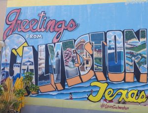
I rode the beach all the way to the San Luis Pass Toll Bridge. It would have been preferable to skip the couple miles of beach within Surfside by using the Bluewater Highway Trail to avoid those crowded beach sections. The toll bridge connects Follet’s Island to Galveston Island. It doesn’t charge anything for cyclists, but it always feels like an unsafe place to ride a bike. After crossing, I quickly returned to the beach and rode the rest of the way to the Galveston Seawall. There’s no beach camping allowed on Galveston Island except the state park which is far out of town and is always booked on weekends way in advance. I grabbed a cheap motel room for the night and enjoyed the afternoon and evening on foot.
Day 10: City of Galveston -> McFaddin Beach Closure
I headed to ShyKatz for breakfast as on previous trips. After enjoying my breakfast, I headed for the Galveston ferry terminal for a ride across to the Bolivar Peninsula. This ferry ride is a longer one that traverses 2.7 miles and takes about 20 minutes. You get some nice views of the bay, ships, and often a few dolphins. Arriving at the other side, I disembarked and rode through the small town of Port Bolivar which bypasses the highway and loops back to Rettilon Rd which is the first beach access. I rode the beach for the next 22 miles until I reached the seawall construction area a few miles before the highway bends north to High Island. Most of this stretch was pleasant for riding except for the very crowded areas around Crystal Beach where I stopped briefly for drinks and snacks. I hopped back on the road and immediately met a constant stream of cyclists headed in the opposite direction.
They were riding the first day of the “Bike Around the Bay” annual two-day fully supported ride and were a bit over 60 miles into their ride. I had encountered them on my October 2022 trip also. I waved to each group as I rode my heavily laden bicycle effortlessly with a tailwind in the the opposite direction. The diverse responses always amuse me. Some surprised, some amused by my heavy touring setup, a couple disapproving scowls (perhaps jealous of my tailwind), and a handful that had clearly bitten off more than they could chew with this ride who could focus on nothing other than their immediate suffering. I’ve looked at their route and it’s not a particularly pleasant one as both days require some riding on interstate highways with either police escorts or lane closures to make it reasonably possible. It highlights how inconvenient, dangerous, and inaccessible large portions of this state are for cyclists.
After a few miles I returned to the beach where the highway bends north and rode out to the closure at McFaddin Beach. Previously, you could continue on for the next 20 miles to Sea Rim State Park, but this portion of the coast is closed to all entry due to much needed beach restoration projects. I’ve ridden this section of beach previously and seen the damage being repaired. It will be nice when it reopens next year.
It is possible to loop around to Sea Rim by going north to Winnie and then riding busy highways to Port Arthur, then down to Sabine Pass, and finally backtracking to the park. I’ve ridden it previously, but had no desire to repeat it on this trip. Adding to the unpleasantness of that route, I’ll never forget coming upon a terrible accident involving two vehicles and another touring cyclist. I made my way to the front of a long line of cars on the shoulder where I encountered the sight of two totaled vehicles and a mangled touring bike. A police officer spotted me and ran over to ask me if I knew the cyclist. Apparently he was deceased and the officers had determined from documents found on him that he was from Germany, but were baffled as to whom to contact.
I turned around at the closure as I had planned at the beginning of the trip. This would be the second point in the trip where I acknowledged the approaching finish of this trip even though I still had over 300 miles left to ride back to Austin. I didn’t have a rigid plan for the ride back to Austin. On the previous two trips, I have looped up and around Houston with Double Lake in the Sam Houston National Forest being the only constant. I decided to ride up to the town of Winnie where I could prepare for the trip back and grab a cheap motel room for the night. After checking the weather and seeing that Double Lake and other campgrounds would not have available sites, I decided I would take a more direct route home.
Day 11: Town of Winnie -> City of Conroe
I was greeted in the morning by unexpectedly dense fog as I made my way to breakfast. There was a nearby McDonald’s which would normally be a last resort breakfast stop. Bizarrely, I find the McGriddle absolutely irresistible on long distance bike tours. Perhaps it is one of the few times my mind can generate sufficient, although not completely logical, excuses to overcome my normal inhibitions to consume such a salt, sugar, and fat laden mound of processed food. Afterwards I set back out in the fog on quiet roads of my auto-generated route until I reached Hwy 90 about 25 miles later. This next stretch of highway shoulder riding was also in my last trip as there aren’t a lot of good options for crossing the Trinity River nearby. At least the shoulder is wide and continuous and the road is flat and straight which is about as safe as it goes for highway riding. Upon reaching Dayton, my route diverged from my previous trip and soon led me to a toll road (Grand Pkwy/SH99). I was initially disappointed with Garmin for leading me here as most tollways around Austin explicitly prohibit bicycles from riding on the shoulder. Since I didn’t see any signs, I just rolled with it. The road appeared to be rather new with little traffic and the full lane, clean shoulder coupled with a noticeable tailwind made for smooth sailing on that stretch.
Exiting the toll road about 8 miles later, I found myself in an unexpectedly dense residential suburb called Plum Creek. It was a busy little town that had obviously outgrown it’s infrastructure with the large housing developments. After leaving here it was mostly quiet roads to the city of Conroe. Like many cities of it’s size in Texas, Conroe’s roads are not designed with cyclists in mind, but I was able to traverse the city without incident. With two long days of riding ahead, I grabbed a motel room and got some good rest.
Day 12: City of Conroe -> Lake Somerville SP
I awoke early to unexpected rain, but it was already tapering off as I set out. I made my second and final McGriddle stop of the trip which provided time for the lingering light rain to dissipate. After cautiously navigating the morning rush hour out of town, I arrived at the William Goodrich Jones State Forest which I had never heard of previously. At only 1,700 acres, it’s small compared to most state forests I’ve visited, but bills itself as one of the largest urban working forests. Its primary focus is “resource education” in the area of “sustained yield forestry.” Yes, you too can learn how to repeatedly clear cut nice forests as profitably as possible. It’s something that I was first exposed to in the Coast Range of Oregon. I admit that a bit of the magic of those forests was lost for me when I realized that it was almost entirely a big tree farm. One positive aspect of the state forests in Texas that differentiates it from many national and other state forests is that they are considered “game sanctuaries” and do not allow hunting or firearms. This particular forest is only open for daylight hours, but otherwise did not seem very restrictive on activities. I enjoyed riding the sandy doubletracks in the park as I passed through. Because of its small size and limited day usage it wouldn’t be a destination to go ride, but it is probably popular with the locals and made for a nice break from the pavement on this ride.
After leaving the forest I soon found myself in an immense residential suburbia. Unfortunately, it was heavily congested with everyone taking their kids to school at this hour. It appeared that there was a nice network of multiuse trails but I stuck to the roads as there were so many young kids and families using the trails. The amount of people riding bikes with their kids on the trails to school made me smile even though the congestion of the area made for a slow roll. The following 25 miles were mostly lesser traffic roads and are not particularly memorable, but weren’t bad. Then I happened upon a sight that I won’t forget.
As I pulled up to the stop sign at an intersection I saw a white ghost bike placed against the fence. These roadside monuments to cyclists that have been killed by cars are unfortunately too common here in Texas. I stopped, as I almost always do, to observe and take a picture. Almost immediately, I felt a sadness far beyond the usual somber observation. In front of me was a child’s ghost bike and it was at an intersection with a school directly across the street.
While writing this report weeks later I looked up the event on the Houston Ghost Bike site. It wasn’t a child hit, but an older cyclist riding with a group of friends. A driver had run the stop sign and t-boned the lead cyclist at speed which sent him flying to his death in the ditch at the northeast corner of the intersection. I also stumbled upon other disturbing stories of drivers in that area intentionally running over groups of cyclists, seriously injuring many and killing others.
I stopped briefly in the town of Hempstead to get a bite of lunch as a rain shower had just caught me. The rain mostly subsided as I rolled back out. There was a 13 mile section of Hwy 290 to follow which sufficed to convey me most directly to my destination and across the Brazos River. I looked out over the river thinking about the last raft crossing of my trip at it’s mouth on the coast just a few days ago. As I neared Brenham, I left the highway and had a pleasant ride through the countryside. I returned briefly to a highway through the town of Somerville. I always find it perplexing that towns like this where the highway is the main road through lose their shoulders and don’t even have sidewalks. Leaving the highway, I looped around to the west end of the lake to my destination.
I arrived at Lake Somerville SP around 3 pm and checked in at the park office. The person in the office was surprised when they asked for my license plate number and I told them I was just traveling by bicycle. They paused for a minute as they decided how to complete the paperwork and said they had never had anyone camping without a car before.
I had arrived a bit earlier than on my previous trip so I spent the remainder of the afternoon hiking on the trails and around the lake. The lake was very low, a reminder of the ongoing severe drought, but it did open up the shoreline for easy exploration. The weather had improved and the area was alive with all kinds of wildlife. I crossed paths with a curious armadillo twice, observed interesting formations of birds soaring in the gusty wind, got swarmed by butterflies, and ran into a few deer. I followed the shoreline and tried to discern all the different animal tracks that had been left there before me. Basking in the late afternoon sun it felt like a warm embrace of nature. It was an unanticipated joy and became the highlight of the trip back to Austin.
Day 13: Lake Somerville SP -> Austin
I set out as the sun was rising on the final ride of my trip. I enjoyed the first 20 miles of rural roads that made their way through a large ranch, a wildlife management area, and the quiet countryside. This was followed by about 20 miles of highway 21 which would have been easily better routed through more of the quiet county backroads. Leaving the highways behind near Paige, I enjoyed more of the rough chipseal and gravel backroads that makes the area a destination for gravel cyclists in Austin. This continued through McDade on a route that I had ridden frequently years ago when I lived east of Austin. I ran into a bridge out on Old McDade Rd, but quickly backtracked around with only adding a few miles. Firmly back on home turf, I made my way on familiar roads through Elgin, Manor, and onto the Southern Walnut Creek Trail. Along the way I was caught in a couple of brief showers, but they just served to remind me how good the weather had been on this trip. I passed by the spot where I had launched my raft on each of my training days before the trip and smiled. I paused and took a photo as I passed over the Colorado River and remembered crossing the mouth at Matagorda Beach. There’s always a satisfaction of completion upon rolling back into my everyday environment.
Conclusion
By almost all quantifiable metrics the trip was a success. I had a window of up to 19 days to complete the trip and finished in 13. I made it up the coast in 5 days which is quicker than I had planned. I traversed Padre Island in both directions faster than ever. I only stopped for a single rest day and never felt physically over extended. I rode some beach sections which I had opted for adjacent roads previously. I had positive interactions with people that I met along the way and interesting encounters with the wildlife. I didn’t get stuck on any islands, flip my raft, or get caught in severe storms, all of which have happened in the past. I also never ran low on food or water. I did have that unexpected crash on the first day as I was leaving Austin, but it was quickly forgotten (except if I sneezed 😆). And there was a couple run-ins with mosquitoes that could have been better avoided.
My equipment loadout was almost identical to the last trip although I made some changes to my bike setup. I had swapped the studded flat pedals for some non-studded flat pedals which was a significant improvement as I didn’t need to remove and then re-install the non-drive side pedal at each raft crossing. I switched back to my regular chain lube (Rock N Roll Extreme) from the more water resistant Silca Synergetic. This was a big improvement as the Synergetic attracts way too much sand to the drivetrain. I also switched from 27.5×2.8 Schwalbe All-round to 27.5×3 Teravail Coronado tires. The Coronado is noticeably larger even though the numbers suggest a small difference. The tires were a big improvement on the sand. There were no issues with my camping setup. I brought a sleeping bag, but it was only cold enough that I used it one night. The only equipment failure was my very old cable lock and some scratches on my cheap sunglasses from the crash.
I spent more nights at motels on this trip than previously. This was primarily due to logistics as I traversed greater distances each day on the coast, the beach out to Sea Rim is still closed, and campgrounds were booked at some locations on the ride there and back. It’s nice to stay at a few along the way as it facilitates the basic necessities like resupplying, cleaning gear, and laundry while also providing easy access to enjoy the other niceties of civilization. However, I would have preferred less on this trip as the camping is one of my favorite aspects of the route.
Has some of the excitement faded now that I have ridden the coast 3 times? Maybe a bit, but that doesn’t mean that I wouldn’t do it again. Have I improved my preparation, equipment, and knowledge of the route to the point that it no longer challenges me? No, although good weather and beach conditions certainly made it seem much easier on this trip. The fact remains that the remote areas of the barrier islands are a harsh environment in a constant state of change. To paraphrase the Greek philosopher Heraclitus: Everything changes and nothing remains still; and you cannot step twice onto the same island.