The Texas Coast Bikerafting Route (TCBR) follows the Texas coast for about 370 miles as it runs runs along the Gulf of Mexico. It is characterized by long barrier islands with large shallow bays. Large stretches of some of the barrier islands remain undeveloped with several of the islands not connected by bridges and can only be reached by watercraft. Man made shipping channels also cut through some of the islands while the mouths of several rivers empty directly into the Gulf. The city of Galveston is the most populated area, but several smaller cities are scattered along the coast as well.
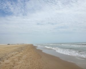
The Texas coast is home to a wide range of landscapes, from sandy beaches and dunes to marshlands and estuaries. It is home to a wide variety of wildlife, including sea turtles, dolphins, and over 400 species of birds. The beaches are composed of soft sand and the waters are warm most of the year.
While a beautiful and fascinating place, there are several aspects that make touring the Texas coast challenging, including: water crossings, lack of roads, lack of fresh water, and the weather. Pointing these out isn’t meant to deter you, but so that you can be adequately prepared and plan accordingly.
Water Crossings
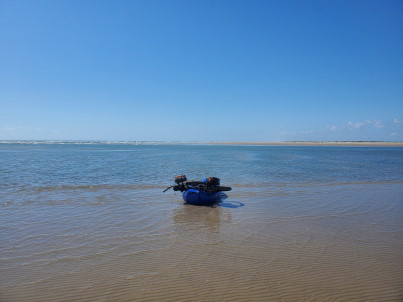
The requirement to cross sections of coastal water ways differentiates this significantly from other bikepacking routes. In general these are all very short crossings, but there simply isn’t a way to make these crossings without a packraft.
These crossings take the form of natural and man made channels and the mouths of several rivers (Colorado, San Bernard, and Brazos).
The free ferry must be used to cross from Galveston to the Bolivar Peninsula. The jetty boat to ferry from Port Aransas to San Jose Island requires a fee.
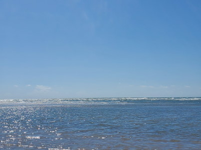
As flat water crossings, the primary hazard that may be present is the weather, and in particular high winds. Large boats may also present a hazard in the shipping channels and should not be crossed when they are present.
Lack of Roads
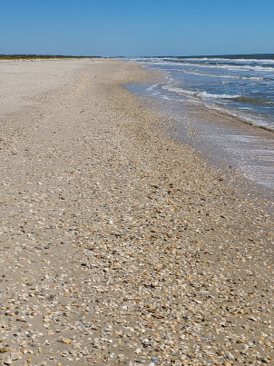
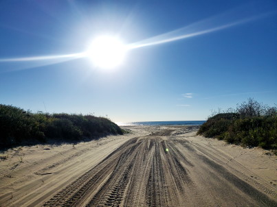
Large sections of the route traverse undeveloped beaches without roads. The beaches are composed of soft sand with few obstacles. In general, the beaches in Texas are good for riding although some stretches require riding closer to the surf and the southern most sections may have very soft sand. Some sections are also filled with shells. The only time I was not able to ride was loose sandy areas entering or leaving a beach. I rode entire route on 2.8″ wide tires, but larger fat tire bikes would be great if you have them.
The northern section from the Freeport area to High Island can be ridden either on the beach or on adjacent parallel running roadways.
The stretch of coast from High Island to Sea Rim State Park was closed to entry for beach remediation efforts in the fall of 2022. I spoke with a park ranger at Sea Rim after the long detour around and learned that this was an ongoing effort taking at least a year. I would check ahead to see if it has reopened and would not recommend the detour.
Lack of Fresh Water
There are significant distances between some resupply points and these remote areas add to the appeal of the route. Carrying enough food for these intervals is not an issue, but carrying sufficient water can become a hassle and does require planning. Water requirements are likely to be higher than most are accustomed to due to sun exposure and heat.
There is no filterable or potable water between supply points. Err on the side of carrying too much water. The route is flat so the extra weight will not significantly slow you down.
Weather
The weather of the Gulf coast can be absolutely fantastic for touring at times, but it can present significant challenges at other times and adequate planning is essential.
Summer and early fall are probably the worst time to try to plan to ride the entire route for two reasons: excessive heat and hurricane season.
While high temperatures during the day may be slightly moderated compared to the interior of Texas during the summer, the low temperatures tend to stay higher at night. Excessive heat will significantly increase water requirements. There may also be nowhere to take refuge from the sun and reflected radiation from the ocean only increases exposure. Sunscreen alone is not sufficient. Sunglasses, full coverage hat, and sun sleeves or long sleeves are generally essential.
Hurricane season takes off in August and typically lasts into October. It is essential to be aware of Gulf weather any time of the year, but during that period it can be difficult to plan a trip in advance. The National Hurricane Center is a good resource to track severe storms. You will not survive a hurricane out on the barrier islands.
Miscellaneous
A variety of minor hazards may be encountered on the route. Insects are not a problem on the beaches, but traveling inland and you can quickly find yourself in mosquito country. This is especially bad on the northern end where there are lots of bayous.
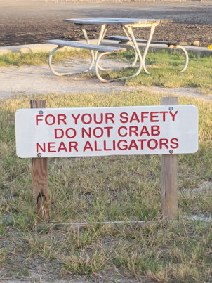
You are unlikely to encounter dangerous large animals, but you should be aware that fresh water ponds and bayous may contain alligators. Nuisance animals that may try to steal your food will be present at established campgrounds and you should hang all food from the supplied poles at these sites.
- Part 1: Intro
- Part 2: Terrain and Environment (You are here)
- Part 3: Rio Grande to Mansfield Channel
- Part 4: Mansfield Channel to Port Aransas
- Part 5: Port Aransas to Matagorda Beach
- Part 6: Matagorda Beach to Bryan Beach
- Part 7: Bryan Beach to Galveston
- Part 8: Galveston to Sea Rim State Park
Notice: Outdoor activities such as those described on this site are inherently dangerous. Effort has been put forth to present factual information but no guarantee is made that it is complete or represents current conditions. You assume all risk with any use of the information on this site.